|
This photo was shown on Earth
Science Picture of the Day for 08-17-2004


Click the images for enlarged view
|
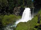
| Location |
In Willamette National
Forest on the McKenzie River in Linn County, Oregon. |
| Access |
National forest recreation
site. Sahalie Falls is a day use area on Route
126, 6 miles south of US Route 20 and 20 miles
north of Mckenzie Bridge. There is a picnic area,
restrooms, and wheelchair accessible path to a falls overlook.
There is a $5 per day use fee or use
a Northwest Forest
Pass or Golden Eagle Pass.
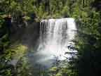
Koosah Falls is accessible from the Koosah Falls
viewing site and the Ice Cap Camp campground, about
1/2 mile south of Sohalie Falls.
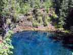
Tamolitch Falls is a moderate 2.5-mile (one-way)
hike from National Forest Rd. 655 about 1/2 mile
north
of
Route 126 near the Trail Bridge powerplant intake
facility.
|
| Hiking |
The Waterfall trail connects
Sahalie Falls and Koosah Falls along the east
side of the McKenzie River. This is an easy, beautiful
trail that will take you about 10-15 minutes one
way.
The trail to Tamolitch Falls (the "Blue Hole")
is through old growth Douglas Fir and Hemlock,
the
last mile
crossing
a lava flow.
You may encounter fairly heavy
mountain
bike
traffic on the trail to Tamolitch Falls,
but
we did not consider this to be a problem. The
bikers were all very considerate of hikers and
the bike
speeds are pretty slow on the difficult (lava
flow) parts of the trail.
|
| Details |
Sahalie Falls and Koosah
Falls are pretty easy to find as is the trail between
the two. To find the trail to Tamolitch Falls, go
5.5 miles south on Route 126 from Sahalie Falls.
Turn right and cross a narrow bridge. Proceed past
a DOT depot to a gravel road and go 0.5 miles to
the trail head.
|
|