|
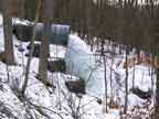
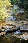 #1
#1 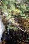
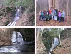
 #2
#2
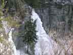
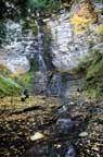 #5
#5 
Click the images for enlarged views
|
| Location |
Lick Brook, a tributary of Cayuga Lake Inlet,
Near Ithaca in Tompkins County. |
| Access
Map
|
Private nature
preserve. Enter via the Finger Lakes Trail through
Sweedler Nature Preserve at Lick Brook. For information,
contact Finger Lakes Land Trust, 202 East Court Street,
Ithaca, NY 14850, 607-275-9487, FingerLakesLandTrust.org.
You can enter the preserve from the top where Lick
Brook crosses Townline Road.
You can also enter from the bottom. Access the
trail from a small, unmarked parking lot just south
of the Route 13 and 34 split, about 5 miles south
of Ithaca. Coming south from Ithaca on 13 and 34,
follow Route 34 South at the split and once through
the interchange, take a left turn to cross over
to the northbound lane of route 13. Then go about
100 yards to the parking lot, just before the bridge.
Walk southeast from the parking lot along the edge
of the field and cross Cayuga Inlet on the railroad
bridge. The trail is to your right just after crossing
the bridge.
|
| Hiking |
Moderate. This hike is on part of the Finger
Lakes Trail and in the gully. If you complete the hike, the total distance is about 3
miles and includes a steep 500' climb. Allow 2-3 hours. |
| Details |
This is a huge gully with
three major waterfalls (47', 25', and 93') and about
a dozen smaller waterfalls and cascades in the 5'
to 12' range. You can scramble up all of the small
falls in the gully or follow the trail. You'll have
to use the trail to get around the large falls. This
is a wonderful hike through a mixed hardwood and hemlock
forest.
After visiting at waterfall #1, continue back on the
trail and climb up the first steep pitch to an overlook above the crest of #1 and across
from the crest of #2. Continue on up the trail for about 100' to a split. The main trail
is on the left and continues up the hill. The smaller trail to the right drops down into
the gully and you can proceed upstream about 1/4 mile to #5 which is an impressive 97 feet
high. Then return to the main trail and continue up beyond the steepest climb when you can
again drop down into the gully (or stay on the trail which follows the rim).
At TownLine road, we turned around and went back down
the trail to our car. |
|